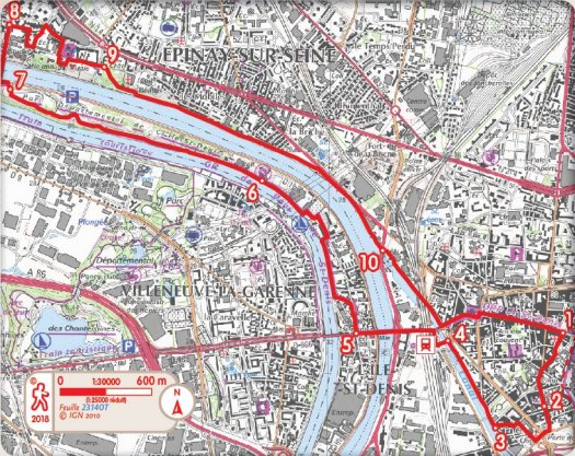
PR1 an island in the middle of a river
The splendid Saint-Denis basilica is the starting point for your walking itinerary heading towards the Seine and Ile-Saint-Denis. This island, this town, is dotted with a magnificent park bordered by the two arms of the Seine. The itinerary also includes the redeveloped banks of the town Epinay-sur-Seine and will allow you to discover the different aspects of the river loop, its landscape, and a never-ending source of inspiration for the impressionists. You will also enjoy its architectural features and havens of nature.
PDF map
- From the place Victor Hugo in front of the Saint-Denis Basilica, turn left towards rue du Cygne. Possible RV at the Tourist Office Center. Continue on towards rue des Boucheries. Turn right onto rue de la Boulangerie.
- Take rue Gabriel Péri slightly to your left, pass in front of the Musée d'art et d'histoire (n°22 bis) and continue on until Porte de Paris. Turn right towards boulevard Anatole France.Be careful crossing it. Take the second street on the right called Bobby Sands until rue du 4 Septembre. Cross place Parmentier. Continue slightly to the left towards rue Raspail. Turn left to reach Quai du Square.
- Go straight forward on Quai du Square and Quai du Port.
- Turn left towards the foootbridge via the stairs. From place de la Gare keep to the left heading towards rue du Port and cross over the Seine using the Pont de l’Île Saint-Denis (bridge). Go straight on via rue Méchin.
- Turn right onto rue de Verdun. Cross Place de la Libération. Turn left heading towards rue Armand and Paul Fumouze. Keep to the right and follow Quai du Saule Fleuri. Go straight on to Promenade des Impressionnistes.
- Walk along the promenade des Impressionnistes, go in to the Parc Départemental de l'Ile Saint Denis. Cross through it to exit onto Quai de la Marine, exit n°2. (There are WC, refreshment bar, exhibitions at the Maison du Parc)
- Turn on your right towards Avenue du Pont d'Epinay and continue on Avenue du 18 Juin 1940 until rue de l’Église. Access the station via rue Gabriel Péri on the left.
- Turn right onto rue de l’Église and right again onto rue du Mont. Take rue Mulot on the left and left again onto rue Monribot. Go straight on towards rue de Paris and right again onto rue du Maréchal Maison. Take the road opposite on the left called rue de l'Abreuvoir to reach rue Claire via your left. Turn left onto rue de la Terrasse and then right onto rue Quetigny.
- Go in to Parc des Beatus and cross it via the right to exit at Chemin de halage. Continue straight along the banks of the Seine until the lock.
- Follow the new cycling and pedestrian track until the bridge, the tramway crossings, lines T 1 and T 8, and RER station. Take rue Auguste Delaune on the left, cross Boulevard Jules Guesde, careful here, take rue de la République on the right to reach Place Victor Hugo and the Tourist Office.